


Maps Department
Opening hours:
- Monday – closed
- Tuesday 2 pm- 6 pm
- Wednesday 10 am – 3 pm
- Thursday 10 am – 3 pm
- Friday – closed
3rd floor, room 352
phone: (+ 48 22) 55 25 885
e-mail: gabkart.buw@uw.edu.pl
History
UW Library cartographic collection, which includes objects spanning the 16th century to the present, has been developed since 1816 when the Library was established. (At that time the cartographic collection was incorporated in the main Library holdings).
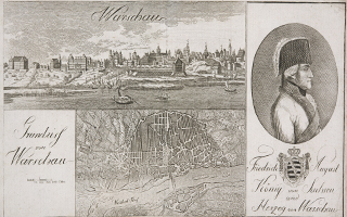
The core of the collection consisted of objects received from monasteries and monastic schools dissolved in the 19th century. The largest number of items were acquired from a postjesuitic library in Kalisz. In that period the collection was enhanced with donations from individuals and institutions (e.g. Komitet Cenzury – the Censorship Committee – which gathered cartographic documents confiscated from citizens sent into exile) and library holdings of dissolved state institutions such as Rada Stanu Królestwa Polskiego (the State Council of the Kingdom of Poland) or Rada Wychowania (the Council on Education). Although in 1819 UW Library began receiving the legal deposit, it was sent by publishers quite sporadically and hardly influenced the size of the collection. In the years 1936-1937 UW Library transferred a large part of its cartographic collection, including General Jan Henryk Dąbrowski’s collection of maps, to the National Library of Poland. During World War II the cartographic collection of Warsaw University Library suffered the loss of approximately 1500 various maps torched in the building of Krasiński Library. In 1949 Warsaw University Library opened its new Cartography Division, renamed in 1956 the Division of Cartographic Collections and in 1996 – the Cartography Department.[zdjecie Zannoni.1]
Collections
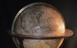
The Department cartographic collection isolated from the Library stock after World War II includes globes, maps, plans and atlases spanning the 16th to 21st century which mainly show the present and historic territories of Poland. Moreover, the Department boasts numerous cartographic objects of very interesting provenance depicting various regions of Europe and the rest of the world. Additionally, next to the objects from the Library “old” cartographic collection, the Department stock consists of the Łańcut collection belonging once to Alfred Potocki and the Nieśwież collection, which is a part of Nieśwież Library holdings once belonging to the famous Radziwiłł family. Finally, the Department collection has been enhanced with donations and so-called „ secured possessions” received after 1945 from the territories of western Poland. At present the Department collection includes over 10,000 items, complete with five 17th and 18th century globes, 67 early printed atlases (dating from the 16th to 18th century), 61 manuscript maps and plans and a plethora of 19th century atlases, maps and plans. Present acquisitions include the legal deposit (mostly plans and topographical maps) and additions to the historic collections (primarily varsaviana and polonica) – the latter acquired as the Library budget permits.
Polonica
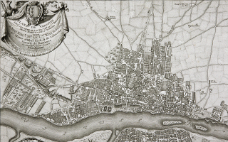
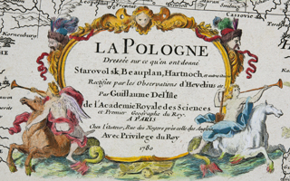
The Department collection of maps of Poland includes numerous rare works of famous Polish cartographers beginning with Wacław Grodecki (1535-1591) whose map entitled Polonia finitimarunque locorum was used by Abraham Ortelius in his atlas published in 1572. The considerable part of the collection consists of works by various European cartographers: the Flemish mathematician and geographer Gerardus Mercator (1512-1594, born Gerhard Kremer) who blazed new trails in cartography, the English cartographer John Speed (1552-1629) and leading German cartographers: Johann Baptista Homann (1664-1724), Matthäus Seutter (1678-1754), Franz Ludwig Güssefeld (1744-1808) and Daniel Friedrich Sotzmann (1754-1840). Additionally, the Department boasts the works of 18th century French cartographers: Robert de Vaugondy, Guillaume Delisle and Edme Mentelle as well as maps by 18th century Italian cartographer Giovanni Antonio Bartolomeo Rizzi-Zannoni (1736-1814). Nineteenth century maps of Poland including works of Polish and other European cartographers draw attention to the changing territorial range of our country. Maps in question are primarily Prussian, Russian and Austrian in origin but the collection also includes Polish objects of high cartographic quality such as the first Polish geological map Carta geologica totius Poloniae, Moldaviae, Transylvaniae, et partis Hungariae et Valachiae made by Stanisław Staszic and published in 1815, Mapa Topograficzna Królestwa Polskiego (The Topographical Map of the Kingdom of Poland) in scale 1: 26,000 created by Kwatermistrzostwo Generalne (the Office of Quartermaster General) and printed in 1828 as well as maps created by Joachim Lelewel, Juliusz Kolberg and Franciszek Rodecki.Moreover, the Department possesses a large collection of maps of Poland dating from the first half of the 20th century, including valuable works of the famous Polish cartographer Eugeniusz Romer (1871-1954), the founder of „Atlas” cartographic institute and first cartographic periodical in the world entitled „Polski Przegląd Kartograficzny” (“Polish Cartography Review”). The Department visitors may also access section maps created by Wojskowy Instytut Geograficzny (the Military Institute of Geography). Contemporary maps of Poland are mainly high-quality topographical maps in scale 1:10,000 and 1:50,000 published by the Surveyor General of Poland. Nineteenth century to modern atlases of Poland have been dominated with geographic, historic and topographical publications by such authors as Joachim Lelewel, Wojciech Chrzanowski, Michał Bazewicz or Eugeniusz Romer. Attention should be drawn to Eugeniusz Romer’s Geograficzno-statystyczny atlas Polski (The geographical and statistical atlas of Poland) published in 1916 which played a significant role in the delineation of the borders of Poland after World War I.Equally important is a subcollection of plans of Warsaw published from the 18th century to the present. The gradually enhanced subcollection includes manuscripts, prints and lithographic prints (some of them extremely rare in Poland) by Polish and foreign cartographers such as Giovanni Rizzi-Zannoni, Joseph Bach, Wilhelm Kolberg and Józef Koriot. Apart from plans of Warsaw the Department collects contemporary and historic plans of other Polish towns and cities.
Foreign cartographic objects
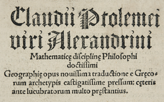
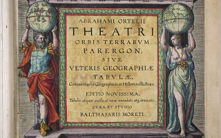
Early printed foreign cartographic objects in the Department collections include works of famous European cartographers: the Flemish cartographers Gerardus Mercator and Abraham Ortelius (Abraham Ortel, 1527-1598, the author of atlas entitled Theatri Orbis Terrarum published in 1624) and the Dutch cartographers Iodocus Hondius (Ioost de Hondt, 1563-1629) and Ioannes Iansonius (Johannes Jansonius / Jan Jansson, 1588-1664) as well as the publications of Antwerpian Officina Plantiniana, Guilielmus Blaeuw (Willem Blaeu, 1571-1638) – the publishing house in Amsterdam and Officina Joannis de Ram (Johannes de Ram, approx. 1648-1696).Attention should be drawn to the work by the Italian cartographer Octavio Pisani entitled Astrologia seu motus et loca siderum published in Antwerp in 1613 and dedicated to the great duke of Toscany Cosimo II de’ Medici.The collection of atlases held by the Department involves items unique or very scarce on a European scale, for instance Ptolemaeus’ Geography illustrated with woodcut maps and published by Joannes Schott in Strasburg in 1513. The large collection of 18th and 19th century atlases includes primarily French and German works but Russian and Polish publications are also included. The collection of cartographic objects showing various regions of Europe and other parts of the world is complemented with city plans and maps created in various techniques.Cartographic objects concerning 16th to 20th century wars and battles form a separate collection of manuscripts, engraved and lithographic atlases, plans and maps. The most interesting works depict the wars for the independence of the Netherlands between Spain and the Netherlands and the war for Spanish succession between the Netherlands and France. The considerable number of plans, maps and atlases, which show troops deployment and movements, concerns the Seven Years War, the Napoleonic Wars and wars between Russia and the Turkish Empire. The unique collection of mostly anonymous manuscript plans of major European fortresses may also be interesting to the Department visitors. World War I is primarily reflected in German maps.
Catalogues
Information on the Department collections may be found in the card catalogs available in the Department reading room:
- the alphabetical catalog of atlases, wall maps, portable maps and plans,
- the catalog of geographical subject headings (divided into atlases, wall maps, portable maps and plans),
- the chronological catalog of atlases,
- the chronological subject catalog of military and war history,
- the alphabetical and subject catalog of reference works.
The reference library (approx. 800 titles) includes such indispensable publications as geographic dictionaries, printed catalogs and informational publications on Polish and foreign cartographic collections, bibliographies of professional literature in the field, publications on cartography and its history, the Polish journal entitled „Polski Przegląd Kartograficzny” („Polish Cartography Review”), and general reference works such as encyclopedias, dictionaries and biographical dictionaries.
Practical informations
- The user may enter the reading room of the Department with the pass issued by the Information Desk staff. In order to receive the pass the user is requested to show valid Library Card and ID card.
- The collections of Warsaw University Library Department of Cartography may be viewed in the reading room of the Department only.
- Reference works and 20th and 21st century objects housed in the Department may be accessed by any user.
- Sixteenth to nineteenth century original maps may be accessed for research purposes by academic staff. Students and postgraduates are requested to present references from their thesis supervisors.
- The Library employees responsible for the Department collections may deny access to some objects if they are in very bad condition.
- Paid copies of objects from the Department collections may be requested for further research from the UW Library Reprographic Services Department.
The details on the availability of the Department collections are provided in The rules for accesing BUW special collections effective from 1st October 2012.